Cosmas Indicopleustes (literally "Cosmas who sailed to India"; also known as Cosmas the Monk) was an Alexandrian Nestorian merchant ,probably a monk and later hermit,[1] He was a 6th-century traveller, who made several voyages to India during the reign of emperor Justinian. His work Topography contained some of the earliest and most famous world maps.
Around 550 Cosmas wrote the once-copiously illustrated Christian Topography, a work partly based on his personal experiences as a merchant on the Red Sea and Indian Ocean in the early 6th century. His description of India and Sri Lanka during the 6th century is invaluable to historians."Indicopleustes" means "Indian voyager". While it is known from classical literature, especially the Periplus Maris Erythraei that there had been trade between the Roman Empire and India from the first century BCE onwards, Cosmas's report is one of the few from individuals who had actually made the journey. He described and sketched some of what he saw in his Topography. Some of these have been copied into the existing manuscripts, the oldest dating to the ninth century.
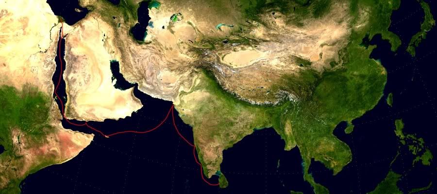
In 522 CE, he visited the Malabar Coast (South India). He is the first traveler (Even though Theophilus surnamed the Indian claimed to be visited Malabar in AD 354 it’s not clear whether he was mentioning about the Arabian peninsula or Malabar) to mention presence of Christians in Malabar unlike Theophilus cosmos give a clear idea about the local flora and fauna of Malabar region which indicate that he actually visited Malabar. He wrote,
"In the Island of Taprobane (Ceylon), there is a church of the Christians, and clerks and faithful. Likewise at Malé where the pepper grows; and in the town of Kalliana there is also a bishop consecrated in Persia.”[2]
Cosmas – a mysterious person

There is quite a controversy about the name of this intriguing author; it started in the seventeenth century, when the Dutch scholar Isaac Voss claimed that Cosmas was not the real name of the author of the Christian Topography, but rather a nickname, prompted by his preoccupation with cosmological matters.[3] It is hard to prove or disprove this statement, but it is a fact that the name Cosmas—as well as the epithet μοναχός, which makes him a monk—only occurs in one of the manuscripts dating from the eleventh century.[4]
All the information we get about Cosmas is gleaned from his work. According to it, he wrote the Christian Topography about twenty-five years after he visited the Ethiopian city of Adule in the year that the Axumite king, Caleb Ella Asbeha[5], went to war against the Himyarites in Southern Arabia. This campaign started sometime between the years 522 and 525, which suggests that the Topography was written between the years 547 and 550 (Top. Chr. 2.54-63).[6] Also, the fact that Cosmas mentions two eclipses appears to corroborate this, as he is probably referring to the solar eclipse on February 6th and to the lunar eclipse on August 17th of the year 547.[7]
However, there is another sort of learning that the Christian whom we call Cosmas regarded as much more valuable than the “pagan” way of instruction—his authorities are the Bible and a certain bishop who deserves our attention:
Nevertheless you ceased not pressing us to compose a treatise, not as communicating opinions and conjectures of my own framing, but what I had learned from the divine scriptures, and from the living voice of that most divine man and great teacher Patricius, (Mar Aba I). Patricius propagated the doctrines of holy religion and true science, and has now by the grace of God been elevated to the lofty Episcopal throne of all Persia, having been appointed to the office of Bishop Catholic of that country. [Top. Chr. 2.2]
[Mar Aba I or Mar Abba the Great was the Patriarch of the Church of the East at Seleucia-Ctesiphon from 540 to 552.[1] He introduced to the church the anaphora of Theodore of Mopsuestia and Nestorius, supplanting the previous liturgical rite of Addai and Mari].
 |
| Mar Abba the Great was the Patriarch of the Church of the East (AD 540-552) |
As stated earlier, it may be uncertain whether Cosmas was indeed a monk; that he was a Christian is beyond doubt. That he was an adherent of Nestorianism is very likely—not only do his cosmological ideas have a Nestorian foundation, as we shall soon see, but his outright veneration for Patricius is telling. This person, a convert from Persian Zoroastrianism, is better known as Aba I. (or with the Syriac honorific title: Mar Aba). He followed and propagated the teachings of Theodore of Mopsuestia and Nestorius and was “Bishop Catholic” (i.e., patriarch) of the Church of the East at Seleucia-Ctesiphon between 540 and 552.[8] Along with Thomas of Edessa, who translated Aba’s Syriac speeches into Greek, he gave lectures on Theodore and Nestorius in Alexandria, and it seems that Cosmas attended them. Patricius and Thomas had to withdraw from that city speedily, though—Nestorianism had been banned as a heresy at the Council of Ephesus in 431, and Alexandria was a strictly anti-Nestorian city. [9]In fact, Nestorius’ main opponent at the Council was the Alexandrian patriarch Cyril. The fact that Cosmas attended these “Heretic lectures” and did not give up his ardent veneration of Patricius/Mar Aba clearly shows that his support for Nestorianism was indefatigable. This, of course, made him a member of a minority group in a somewhat hostile environment, and it may well have been the main reason for the author of the Christian Topography to hide so cautiously behind his work.
There is yet another side to Cosmas, though. As he states himself, he used to be a merchant in his former life; as such, he has travelled to the Aksumite Empire in Ethiopia, as mentioned before. Explicitly, he also mentions having sailed around the island of Socotra (Top. Chr. 3.65) and having ventured into what he calls “three gulfs”:
Having learned these facts from the Man of God, as has been said, I have pointed them out as coincident also with my own experience, for I myself have made voyages for commercial purposes in three of these gulfs – the Roman, the Arabian and the Persian, while from the natives or from seafaring men I have obtained accurate information regarding the different places. [Top. Chr. 2.29]

The bodies of water Cosmas refers to are the Mediterranean, the Red Sea and the Persian Gulf. These two aspects—devout Nestorian Christian doctrine combined with a vast personal travelling experience—are the two parameters we must keep in mind to further understand Cosmas’ work. It should be noted, however, that Cosmas himself does not see a dichotomy between these two “worlds”, as might be expected. Convinced by the speeches of Mar Aba, he still does not belittle or conceal his mercantile past, but finds the knowledge he acquired back then to be in keeping with his newly won convictions.
Another important detail from this short passage should be highlighted: So far, it has only become clear that Cosmas thought highly of the city of Alexandria (Top. Chr. 2.1) and may have associated it with notions of home. By referring to the Mediterranean Sea as a “[gulf stretching] towards the Roman Empire” he reminds us that Egypt then formed a part of the Byzantine Empire. ‘Romania’ was one of the contemporary terms the Byzantines used when referring to their empire, as does Cosmas on four occasions.[10] He also uses the adjective (Roman) and always speaks of ‘Romans’ when he refers to Byzantine subjects. With (Greeks), he only refers to the ancient or Hellenistic Greeks and almost always uses the word in the sense of ‘pagan’. [11] This is also in keeping with Byzantine terminology. It may be argued that the use of Byzantine phrases does not necessarily prove Cosmas to have been a legal subject of the Emperor of Constantinople,[12] but it certainly does show that he was influenced by Byzantine culture.
The Christian Topography
Within the mental framework mentioned above, Cosmas unfolds much more than the title of his work may suggest. The Christian Topography is not only a travelogue of places that might be interesting to a Christian, but it comprises both cosmology and geography. Its major aim is to propagate a “truly” biblical view of the world.
Cosmas, in book 10, quotes from the works of the Church fathers to show that his doctrines are in keeping with the official teachings.

The Christian Topography could have stopped at this point, since the concept as a whole had been explained sufficiently and the critical questions had been answered—perhaps not to the complete satisfaction of those who had raised their doubts, but certainly to the extent that Cosmas was willing and able to deal with them. Still, the ten books described above are not all that is featured in the codices; there seems to have been a third edition, probably posthumously, of Cosmas’ Topography together with two of his works that are otherwise lost, a Geography and an Astronomy. Horst Schneider, in an article from 2006, argues that the two additional books we have in our edition of the Topography are excerpts from the Geography and the Astronomy respectively.[13]Book 11 supports this claim, because it features a description of animals and plants from Africa and India, as well as an account of the island of Sri Lanka.On the other hand, book 12, which demonstrates how several old pagan writers bore testimony to the antiquity of the Old Testament scriptures, is difficult to accept in the context of an astronomical treatise. It certainly was not intended to be part of the Topography.Since several differences between the codices, in which the Christian Topography is extant, have been mentioned, a few words should be written about the nature of these manuscripts. The oldest of them is the Vaticanus graecus 699. It was written in uncial characters in the ninth century at Constantinople; it is currently kept at the Vatican library. It only contains books 1 to 10.The other two extant codices are both from the eleventh century. The Sinaiticus graecus 1186 was written in Byzantine minuscules, probably in Cappadocia, and is now located in the library of St. Katherine’s monastery on the Sinai Peninsula. Of the three this codex is the best preserved and contains books 1 to 12.The Laurentianus Plut. IX. 28, also in minuscules, was probably written at Iviron monastery on Mount Athos and is now at the Laurentian library at Florence. Like the Sinaiticus, it contains books 1 to 12. [14]
In the book (Top. Chr. 2.47 and 48), Cosmas gives figures for the earth’s dimensions from China in the east to Cádiz in the west, and from the northerly Hyperboreans to Ethiopia in the south. He arrives at the rather unsurprising conclusion that the ratio of length and breadth is 2:1 and, therefore, correlates with Moses’ figures.
The ocean in this image clearly surrounds the earth and separates it from paradise, which is located at the eastern end. The flowery “paradise in Eden” is a reality for Cosmas, although he stresses that it is separated from the earth by a stretch of impassable ocean. Consequently, the four main rivers of the world, the Phison, identified as Ganges/Indus (which Cosmas thought to be one and the same, cf. Top. Chr. 2.81), the Nile, the Euphrates and the Tigris, which have their origin in biblical Paradise, have to wend their courses under the ocean into the earthly realms.
Cosmas and the Far East
Cosmas had good sources on trade routes and on matters of local flora, fauna and geography is a fact. Most of the material relevant for our purpose comes from book 11 of the Christian Topography, that is, from the book which is, in all probability, an excerpt from Cosmas’ otherwise lost Geography. The texts relating to the Far East are embellished with illustrations of a third category. They are neither taken from illustrated Bible editions, nor designed to visualize theories, but were adapted from what Cosmas had actually seen in various places. A few of them may serve as examples.

There is another exotic illustration that has caused some controversy—one commonly called Gazelle and Palm Trees. This picture is notoriously misplaced in the codices. In the Vatican manuscript, it appears in the description of Cosmas’ Adulitic adventure (Top. Chr. 2.55), while in the Sinaitic and the Laurentian codex it is erroneously placed in book 6, chapter 34 (talking about the different climates of the earth). Most scholars have thought that this picture belongs to book 11 and claimed that the confusion arose when the compiler who formed the present edition of the Christian Topography from the (no longer extant) “Complete Works” of Cosmas made a mistake.[15]
The picture’s caption reads:
“These are the so-called ‘mozá’, the Indian date palms”
If Cosmas indeed saw these trees and, moreover, heard the word ‘mozá’ in connection with date palms, it could for the first time be said that the epithet ‘Indicopleustes’ contains some truth. In modern India there are no date palms, but in the Indus Valley, which now belongs to Pakistan, and was in Cosmas’ time regarded as a part of India, date palms grow abundantly. In the Makrān region, the major part of which belongs to Balochistan, one of the most highly praised varieties of dates is called ‘mozāti’. This could be the etymon for Cosmas’ word ‘mozá’.[16]
Dates were perhaps one of the commodities Cosmas traded in; another with which he was familiar was silk, one of the most significant import goods of the Byzantine Empire.[17] In Top. Chr. 2.45f. Cosmas describes in some detail the origin of silk and the trade routes along which it could be imported:
Now this country of silk is situated 
in the remotest of all the Indies, and lies to the left of those who enter the Indian sea, far beyond the Persian Gulf, and the island called by the Indians Selediba and by the Greeks Taprobanê. It is called Tzinista, and is surrounded on the left by the ocean, just as Barbaria is surrounded by it on the right. The Indian philosophers, called the Brachmans, say that if you stretch a cord from Tzinista to pass through Persia, onward to the Roman dominions, the middle of the earth would be quite correctly traced, and they are perhaps right. For the country in question deflects considerably to the left, so that the loads of silk passing by land through one nation after another, reach Persia in a comparatively short time; whilst the route by sea to Persia is vastly greater. For just as great a distance as the Persian Gulf runs up into Persia, so great a distance and even a greater has one to run, who, being bound for Tzinista, sails eastward from Taprobanê; while besides, the distances from the mouth of the Persian Gulf to Taprobanê; and the parts beyond through the whole width of the Indian sea are very considerable. He then who comes by land from Tzinista to Persia shortens very considerably the length of the journey. This is why there is always to be found a great quantity of silk in Persia. Beyond Tzinista there is neither navigation nor any land to inhabit.
in the remotest of all the Indies, and lies to the left of those who enter the Indian sea, far beyond the Persian Gulf, and the island called by the Indians Selediba and by the Greeks Taprobanê. It is called Tzinista, and is surrounded on the left by the ocean, just as Barbaria is surrounded by it on the right. The Indian philosophers, called the Brachmans, say that if you stretch a cord from Tzinista to pass through Persia, onward to the Roman dominions, the middle of the earth would be quite correctly traced, and they are perhaps right. For the country in question deflects considerably to the left, so that the loads of silk passing by land through one nation after another, reach Persia in a comparatively short time; whilst the route by sea to Persia is vastly greater. For just as great a distance as the Persian Gulf runs up into Persia, so great a distance and even a greater has one to run, who, being bound for Tzinista, sails eastward from Taprobanê; while besides, the distances from the mouth of the Persian Gulf to Taprobanê; and the parts beyond through the whole width of the Indian sea are very considerable. He then who comes by land from Tzinista to Persia shortens very considerably the length of the journey. This is why there is always to be found a great quantity of silk in Persia. Beyond Tzinista there is neither navigation nor any land to inhabit.
As Pigulewskaja points out,[18] Cosmas was the first to stress the two possible routes to and from China: the overland Silk Road, along which Persia played a major part (even the name Cosmas uses for China, Tzinista, is obviously derived from IranianCinistan), and the so-called Silk Road of the sea, along which the island of Taprobanê (Sri Lanka) was an important entrepôt. Cosmas says the sea route is longer because China has a curved coastline, which it has, but the difference in length of the routes could be better accounted for when considering the extension of India towards the south, which Cosmas underestimates, judging from his world map (figure 7), and with the existence of the Malay peninsula, which Cosmas is not aware of at all.

His mention of the Indian philosophers as a source for geometrical knowledge in the literal sense of the word is also interesting. These philosophers likewise had the concept of Mount Meru, as mentioned above, and could have introduced Cosmas to it, whether by personal or indirect communication, or by means of written works. At any rate, it is worth noting that Cosmas not only draws on what he had seen in far-away regions, but also on what he had learned from a certain intellectual elite residing there. This shows his vital interest in other cultures and his perplexing readiness towards receiving knowledge from them. This demonstrates, again, Cosmas’ rationale: his rejection of ideas originating from non-Christian beliefs, his interest in all things non-Christian, and his acceptance of whatever follows his personal view of Christianity and his cosmological model.
Being a merchant who apparently favoured sea routes, Cosmas devotes much of his text to the subject of trade between eastern Africa and the Indian region. As in the passage above, Sri Lanka, whose name S(i)elediba, which is a derivation ofSihaladipa/Singhaladvipa (‘island of the Sinhalese’), Cosmas is the first to mention with certainty, plays a major role:
The island being, as it is, in a central position, is much frequented by ships from all parts of India and from Persia and Ethiopia, and it likewise sends out many of its own. And from the remotest countries, I mean Tzinista and other trading places, it receives silk, aloes, cloves, sandalwood and other products, and these again are passed on to marts on this side, such as Male, where pepper grows, and to Calliana, which exports copper and sesame-logs, and cloth for making dresses, for it also is a great place of business. And to Sindu also where musk and castor is procured and spikenard,[19] and to Persia and the Homerite country, and to Adulé. And the island receives imports from all these marts which we have mentioned and passes them on to the remoter ports, while, at the same time, exporting its own produce in both directions. [Top. Chr. 11,15]

Silk and its country of origin are mentioned again, as are many other commodities with their origins and destinations. Pepper is among them, which according to Cosmas grows in Male. Here he does not refer to the capital island of the Maldives, but to the Malabar coast in south-western India (cf. figure 12). This stretch of land is sometimes called “pepper coast” even today.
Details like these also suggest that it is likely that Cosmas travelled to India, although he could have copied some of the data from other merchants’ logs or handbooks.[20] He does have an illustration of pepper vines, though, and a text along with it, both of which are so detailed and accurate that personal inspection and experience are almost a certainty:
This is a picture of the tree which produces pepper. Each separate stem being very weak and limp twines itself, like the slender tendrils of the vine, around some lofty tree which bears no fruit. And every cluster of the fruit is protected by a double leaf. It is of a deep green colour like that of rue. [Top. Chr. 11.10]
As mentioned before, Cosmas paid a lot of attention to the island of Sri Lanka. His remarks on it have been extensively scrutinized by scholars in recent years.[21] Because of this, I would like to confine myself to a few passages that seem pertinent in our context.
In Top. Chr. 11.13, Cosmas tells us about Sri Lanka:

This is a large oceanic island lying in the Indian sea. By the Indians it is called Sielediba, but by the Greeks Taprobanê, and therein is found the hyacinth stone. It lies on the other side of the pepper country. Around it are numerous small islands all having fresh water and coconut trees. They nearly all have deep water close up to their shores.
It is true that Sri Lanka is a fairly big island, but not as big as the ancients thought it was. Like them, Cosmas overestimates its size, perhaps induced by local measurements and by the important role it played in trade. The numerous little islands around Sri Lanka do not exist, but it may be that Cosmas here alludes to the over 1000 little islets of the Maldives, most of which have coconut trees and fresh water. The islets on the outer reefs of the atolls are indeed close to deep water. [22]
Cosmas witnessed coconut trees and how they are harvested. In Top. Chr. 11.11, he presents us with the following picture:

The text that accompanies the drawing of the “Indian nuts” (κάρυα Ἰνδικά) also calls them ἀργέλλια - a word already found in the passage discussed above (Top. Chr. 11.13). This is likely to be a derivation of Sanskrit narikela (meaning ‘coconut’ or ‘coconut tree’), probably by way of Sinhalese and/or Persian mediation. Apart from that, Cosmas shares first-hand information about the trees' appearance, the taste of their nuts and their contents. According to him, the Indians also make an alcoholic drink from the coconut water—here he may have been mistaken because the toddy he perhaps tasted is not made from coconut water, but from the sap of palm blossoms.
In the last few passages, as we became familiar with Cosmas as a merchant, his ardent Christian side seems to have receded. Still, it is there, even in those passages in which Cosmas deals with apparently worldly matters. On two occasions (Top. Chr. 3.65 and 11.14) he proudly tells us about a small group of Christians in Sri Lanka. Significantly, this is the first mention of Christians on Sri Lanka. The second passage reads as follows:
Ἔχει δὲ ἡ αὐτὴ νῆσος καὶ Ἐκκλησίαν τῶν ἐπιδημούντων Περσῶν χριστιανῶν καὶ πρεσβύτερον ἀπὸ Περσίδος χειροτονούμενον καὶ διάκονον καὶ πᾶσαν τὴν ἐκκλησιαστικὴν λειτουργίαν. Οἱ δὲ ἐγχώριοι καὶ οἱ βασιλεῖς ἀλλόφυλοί εἰσιν.
The island has also a church of Persian Christians who have settled there, and a Presbyter who is appointed from Persia, and a Deacon and a complete ecclesiastical ritual. But the natives and their kings are heathens. [Top. Chr.11.14]
The fact that the Christians are all Persian expatriates—including the believers, the priest and probably the deacon—definitely has a special meaning to Cosmas. These people were from the same country as his revered teacher, Mar Aba, and they were East Syrians (i.e. Nestorians).
Cosmas and the Malabar Coast(Male)

The seaports mentioned in the records of this period must have served as the natural outlets of the import and export trade borne along long-distance routes from the interior.
From the remotest countries, I mean Tzinista and other trading places, it Taprobanê. (ie Sri Lanka) receives silk, aloes, cloves, sandalwood and other products, and these again are passed on to marts on this side, such as Male,(ie Malabar) where pepper grows, and to Calliana(Un identified) which exports copper and sesame-logs, and cloth for making dresses, for it also is a great place of business. …….And to Sindu(port city of Karachi in Sindh) also where musk and castor is procured and androstachys, and to Persia and the Homerite country (Yemen). Sindu is on the frontier of India, for the river Indus, that is, the Phison, which discharges into the Persian Gulf, forms the boundary between Persia and India.
The most notable places of trade in India are these: Sindu, Orrhotha, Calliana, Sibor, and then the five marts of Male which export pepper: Parti, Mangarouth, Salopatana, Nalopatana, Poudopatana. Then out in the ocean, at the distance of about five days and nights from the continent, lies Sielediba, that is Taprobanê.
But, in the direction of the notable seats of commerce already mentioned, there are numerous others [of less importance] both on the coast and inland, and a country of great extent. Higher up in India, that is, farther to the north, are the White Huns. The one called Gollas when going to war takes with him, it is said, no fewer than two thousand elephants, and a great force of cavalry. He is the lord of India, and oppressing the people forces them to pay tribute. A story goes that this king once upon a time would lay siege to an inland city of the Indians which was on every side protected by water. A long while he sat down before it, until what with his elephants, his horses and his soldiers all the water had been drunk up. He then crossed over to the city dry-shod, and took it. These people set great store by the emerald stone and wear it set in a crown. The Ethiopians who procure this stone from the Blemmyes in Ethiopia take it into India and, with the price it fetches, they invest in wares of great value. All these matters I have described and explained partly from personal observation, and partly from accurate inquiries which I made when in the neighborhood of the different places.
From Bk. XI
Male means the coast of Malabar, Now Adule is 'Thulla or Zula on Annesley Bay, Sindu means the lower valley of Indus[The Persian empire when overthrown by Alexander the Great extended to the Indus, and even embraced territories lying eastward from that river].Pliny mentions an Indian race called the Horatae, who adjoined the Gulf of Cambay. Orrhotha-The name an incorrect transcription of soreth, a. form of Sauxashtra. the Surastrene of the Periples and of Ptolemy, It is now in Gujarat & It cannot be Surat, since this was not a place of any importance till Portuguese timu. Orrhotha seem to have been a port on the western coast of the Gujarat peninsula,Sibor probably Chaul, a seaport lying about twenty-three miles to the south of Bombay i.e. This port is the Simylla of Ptolemy. and the Saimur or Jaimur of the Arabian geographers. Mangarouth, is Mangalor. The termination patana in these three names [Salopatana, Nalopatana, Poudopatana.] means town. Poudopatana[New town] is the Podoperoura of Ptolemy. Thue three places were situated on the coast of Kottonarike—the pepper country male.[23]
NOTES:
[1] Beatrice Nicolini, Penelope-Jane Watson, Makran, Oman, and Zanzibar: Three-terminal Cultural Corridor in the Western Indian Ocean (1799–1856), 2004,
[2] Travancore Manual, page 248.
[3] Eric O. Winstedt, ed., The Christian Topograpy of Cosmas Indicopleustes (Cambridge: Cambridge University Press, 1909), 2.
[4] Laurentianus Plut. IX. 28 (now at the Laurentian library at Florence).
[5]Ella Asbeha (‘the one who brings in the dawn’) was the royal epithet of Caleb, son of Tazena, who became king of the Ethiopian Empire of Axum in 515 A.D. and is called Ἐλλατζβάας by Cosmas (Top. Chr. 2.56). For further information on this king, who also was made a Christian saint, and on the inscriptions referring to him, see Wolfgang Hahn, “Der Heilige Kaleb Ella Asbeha – König des Abessinierlandes und seine Münzen,” Money Trend 3 (2000): 60-67.
[6]More on Cosmas’ Ethiopian adventure can be found in Laurence P. Kirwan, “The Christian Topography and the Kingdom of Axum”, The Geographical Journal 138, no. 2 (June 1972): 166-177.
[7]The passage in question is Top. Chr. 6.3. See Jakob Krall, “Studien zur Geschichte des alten Aegypten, IV. Das Land Punt,” 11. Abhandlung der Sitzungsberichte der kaiserlichen Akademie der Wissenschaften, Philosophisch-Historische Classe, 121 (Vienna: F. Tempsky, 1890) 72, Ann. 2; Winstedt The Christian Topograpy of Cosmas Indicopleustes, 5, Ann. 2; Bernhard Schleißheimer,Kosmas Indikopleustes: Ein altchristliches Weltbild (München: W. u. J.M. Salzer, 1959), 6 (misrepresenting the date for the solar eclipse as Feb. 2nd); Wolska-Conus vol. I, 1968, 16 (erroneously referring to two solar eclipses, just like Nina V. Pigulewskaja,Byzanz auf den Wegen nach Indien: aus der Geschichte des byzantinischen Handels mit dem Orient vom 4. bis 6. Jahrhundert, überarb. dt. Ausg. (Berlin: Akademie Verlag, 1969), 112).
[8]For further information on Mar Aba- Patricius see Adrian Fortescue, The Lesser Eastern Churches (London: Catholic Trust Society, 1913), 82f., Oskar Braun, Ausgewählte Akten Persischer Märtyrer (Kempten: Kösel, 1915) and Schleißheimer Kosmas Indikopleustes, 9f.
[9]See Anastos “The Alexandrian Origin,”, esp. 76f. The Nestorians made a strong distinction between the man Jesus and Jesus as the divine son of God and believed that there were two persons in Jesus Christ; monophysitism, the position considered “orthodox” after the Council of Ephesus and the one prevalent in Egypt at least until 518, held that Christ was one person and had only one nature, his humanity being absorbed by his deity. At the Council of Chalcedon in 451, however, monophysitism was also declared heretic and replaced by the dogma that there were two inseparable natures in the one person of Jesus Christ. However, the patriarch of Alexandria and the other bishops of Egypt refused to accept the dogmata of Chalcedon, because they seemed to represent a new version of Nestorianism to them. Until Cosmas’ lifetime, the Byzantine emperors tried to enforce the orthodox (i.e. Chalcedonian) position. Even now the Coptic Church is monophysite (or “miaphysite” in post-Chalcedonian terminology).
10 Apart from Top. Chr. 2.29 also in 2.45, 2.75 and 11.23.
11 McCrindle felt obliged to explain his translation of Ἕλληνες as ‘pagans’ throughout the Christian Topography like this: “In the days of Cosmas it was used, not so much to designate persons of Hellenic descent, as persons who clung to the old superstitions of Greece and Rome and rejected Christianity.” Ibid., xi.
12 For instance, owing to Byzantine influence, the Arabs continued to call the Mediterranean Sea ‘Sea of Rome’ (Baḥr al-Rūm) until the end of the nineteenth century, although they were never subjects of the Byzantine Empire.
13 Horst Schneider, “Kosmas Indikopleustes, Christliche Topographie: Probleme der Überlieferung und Editionsgeschichte,”Byzantinische Zeitschrift 99/2 (2006): 605-614.
14 For more details on the codices see Wolska-Conus, vol. I, Cosmas Indicopleustès, 45-50.
15 See for instance, Wolska-Conus, Cosmas Indicopleustès, vol. 1, 173f.
16 Cf. R. alph Hughes-Buller, ed., Imperial gazetteer of India: Provincial series: Baluchistan (Calcutta: Superintendent of Gov. Print, 1908), 36: “Throughout Makrān the staple food is dates. [...] Though all the trees belong to the species Phoenix dactylifera, they are distinguished locally into more than a hundred kinds, according to weight, size, and quality of the fruit. All trees are known either as pedigree trees (nasabi) or non-pedigree trees (kuroch). Among the former the best varieties are mozāti, āp-e-dandān,haleni, begam jangi, and sabzo.” I must admit that, when I first saw the word μοζᾶ next to the image of the tree, my impression was that this was a rendering of Arabic (and Persian) moz, meaning ‘banana’ (in fact, this is the etymon of Linnés scientific name for ‘banana’, Musa, and the banana-like plants, Musaceae). Later I discovered Winstedt had come across that idea already (1909, 16). On closer inspection, however, the plant Cosmas depicts does not so much resemble a banana tree, but really a date palm, as most scholars (including Wolska-Conus) have assumed and expressed by way of their captions to the picture (none of them have commented on the word μοζᾶ, though). In the light of the term mozāti referring to dates, I think Winstedt’s otherwise attractive ‘“banana hypothesis’ hypothesis” should be laid to rest.
[17] On the importance of silk for Byzantium see Pigulewskaja Byzanz auf den Wegen nach Indien, 80-87.
[18] Ibid., 126.
[19] McCrindle has “androstachys” in his translation, which is also what the codices give. But since this word is unknown, he suggests that this is a misspelling of nardostachys, which is the Greek term for spikenard. See McCrindle The Christian Topography of Cosmas, 366, esp. note 7. Wolska-Conus has emended this word in her Greek text, so the translation should also be changed accordingly.
[20] One might think of Byzantine, but also of Syriac, Persian, Arabic, Himyarite or Ethiopian manuals—at least the merchants Cosmas most probably came into contact with in Egypt would be from these regions. Unfortunately, no such manual is extant for the time in question or anytime close. A few works Cosmas may have used, or ones that show at least some parallels with the route to India are as follows: I. A treatise from the middle of the fourth century, containing geographical and commercial information, extant in two Latin versions and commonly called Expositio totius mundi et gentium. See Pigulewskaja Byzanz auf den Wegen nach Indien, 46-50 and 100-109, as well as Franz Peter Mittag, “Zu den Quellen der Expositio totius mundi et gentium. Ein neuer Periplus?”, Hermes 134 (2006): 338-351. II. A very short treatise the author of the Expositio may have used is called Ὁδοιπορία ἀπὸ Ἐδὲμ τοῦ παραδεῖσου ἄχρι τῶν Ῥωμαίων (“Journey from Eden, the paradise, to the Romans.”) See Alfred Klotz,Rheinisches Museum, N.F. 65 (1910): 606-616,as well as Pigulewskaja Byzanz auf den Wegen nach Indien, 100-109 and 323f. Perhaps Cosmas knew its contents, which may have sparked his effort to prove that paradise is contiguous with earthly realms inTop. Chr. 2.43-45. III. A curious report about a lawyer from Egyptian Thebes, from the fifth century, travelling via the Axumite kingdom to Sri Lanka, preserved in a treatise on the Brahmans by Palladius. See J. Duncan M. Derrett, “The History of ‘Palladius on the Races of India and the Brahmans,’” Classica et Mediaevalia 21 (1960): 64-135, as well as Don Patrick Mervyn Weerakkody,Taprobanê – Ancient Sri Lanka as known to Greeks and Romans (Turnhout: Brepols, 1997): 119-131, and Stefan Faller,Taprobane im Wandel der Zeit (Stuttgart: Steiner, 2000): 142-151. IV. The historical work of Ammianus Marcellinus (late fourth century), V. The ecclesiastical history of Philostorgios (early fifth century; only an excerpt compiled by Photios survives) and VI. The Historia arcana of Procopius (sixth century) all feature references to Byzantine commerce with the east, although not systematically. The list of these works is not meant to suggest that Cosmas copied large portions, or anything at all from them—in fact, his accounts about eastern regions exceed them and are far too lively to be the result of mere compilation—but they are meant to show that in Cosmas’ lifetime and the immediately preceding centuries India, Sri Lanka, China and their commercial goods were of great interest to the Byzantines.
[21] Franz Ferdinand Schwarz, “Kosmas und Sielediba,” Živa antika (Antiquité vivante) 25 (1975): 469-490; WeerakkodyTaprobanê–Ancient Sri Lanka as known to Greeks and Romans,133-144; Faller Taprobane im Wandel der Zeit, 151-161.
[22]Stefan Faller, “Die Malediven und Lakkadiven in griechischen und lateinischen Quellen,” in: Stefan Faller, ed., Studien zu antiken Identitäten (Würzburg: Ergon, 2001), 163-192.
No comments:
Post a Comment